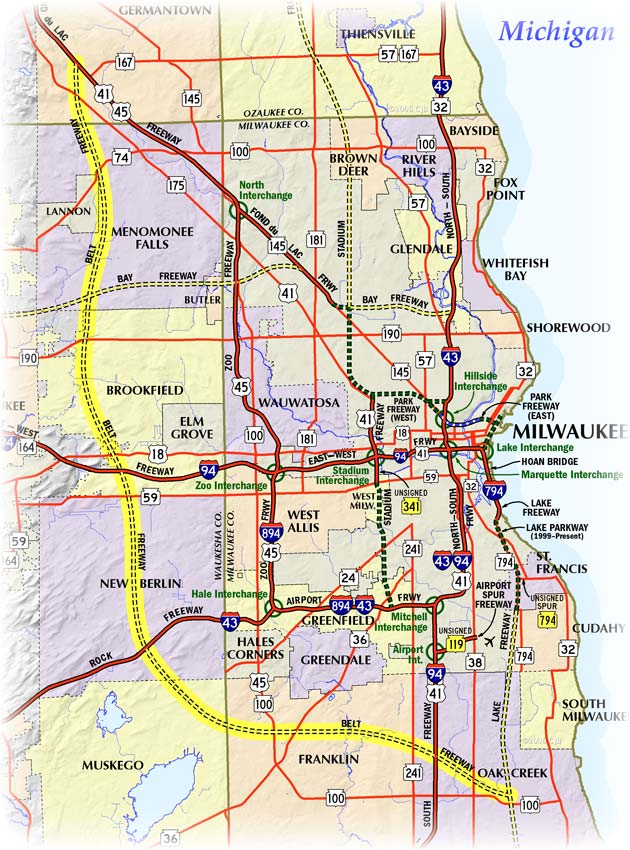
Milwaukee Freeways: Belt Freeway
The Belt Freeway was a proposed-but-never-built 33-mile long freeway which would have formed an "outerbelt" of sorts around the south and west sides of the Milwaukee metropolitan region, running approximately four to six miles outside the existing Milwaukee "bypass" route consisting of the Airport and Zoo Freeways.
The freeway would have begun at the Lake Freeway in Oak Creek and proceeded
northwesterly intersecting the I-94/North-South
Freeway near Puetz Rd and
swung westerly, crossing STH-36/Loomis Rd and US-45/STH-100/Lovers Lane Rd
near Drexel Rd in Franklin. From there, the freeway would have turned northwesterly,
clipping the northeastern corner of Muskego and intersecting the I-43/Rock
Freeway west of the CTH-O/Moorland Rd interchange before turning northerly
through the rest of New Berlin via the Calhoun Rd corridor. The Belt was
to have intersected the I-94/East-West Freeway west of Calhoun Rd, about
two miles east of the US-18/Bluemound Rd interchange, in Brookfield and continued
northwesterly then northerly again between Barker and Brookfield Rds. In
Menomonee Falls, the freeway was to have continued northerly approximately
one mile east of Lannon Rd, running along the eastern boundary of the City
of Lannon and bypassing downtown Menomonee Falls to the west, 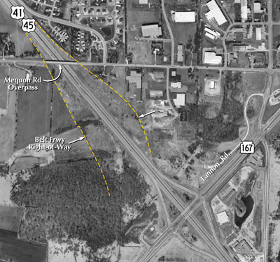 before entering
Germantown where the freeway would have terminated at US-41/US-45 at the
Mequon Rd overpass.
before entering
Germantown where the freeway would have terminated at US-41/US-45 at the
Mequon Rd overpass.
In fact, the Mequon Rd overpass, the next one north of the STH-167/Lannon Rd interchange, is the only visible evidence of the Belt Freeway ever constructed. The overpass structure itself was constructed with two very wide side spans to accommodate the ramps to and from the Belt as it connected into US-41/US-45. Aerial photography from modern times also shows evidence of the right-of-way purchased by the state to accommodate the Belt Freeway interchange, even today. Beyond these two pieces of physical evidence, no other evidence at any other location is known to exist today.
Land purchased by WisDOT in late 1972 for the Belt Freeway's interchange with US-41/US-45 was sold to a developer in June 1999. The 16-acre tract was located on the east side of Lannon Rd between the freeway and STH-175/Appleton Ave and was purchased from the state for $221,500.
Note: The map below will be updated in the near future to show the many route designation changes from 2015.