
STH-131 in the Kickapoo Valley
 STH-131 runs up the Kickapoo River valley for its entire length except for
the northernmost portion of the highway, which overshoots the river valley
by about twenty miles from Ontario to Tomah. Otherwise, the highway begins
near the mouth of the Kickapoo on the Wisconsin River east of Wauzeka and
stays on the east side of the river for almost thirty miles. At Soldiers
Grove, STH-131 begins to alternate on different sides of the river all the
way into Ontario. Its this relationship to the river which has colored so
much of the past of this highway.
STH-131 runs up the Kickapoo River valley for its entire length except for
the northernmost portion of the highway, which overshoots the river valley
by about twenty miles from Ontario to Tomah. Otherwise, the highway begins
near the mouth of the Kickapoo on the Wisconsin River east of Wauzeka and
stays on the east side of the river for almost thirty miles. At Soldiers
Grove, STH-131 begins to alternate on different sides of the river all the
way into Ontario. Its this relationship to the river which has colored so
much of the past of this highway.
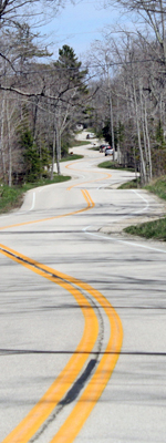
While STH-131 extends for nearly 80 miles from STH-60 near Wauzeka to US-12 & STH-16 on the south side of Tomah, this article deals mainly with that 14 mile stretch from LaFarge to Ontario in Vernon County's "panhandle" area. Comprising less than 20 percent of the highway's overall length, this segment has been home to most of STH-131's controversy over the years, involving a failed dam and impoundment project, abandoned segments, quaint bridges and its share of dangerous curves.
The original route for STH-131 existed only in Crawford County and did not make it north of Soldiers Grove until 1939 when it was extended northerly via US-61 to Readstown and then northeasterly via CTH-M to end at LaFarge. Nearly a decade later in 1948, STH-131 was again extended northerly from LaFarge via CTH-M through Rockton and Ontario to Wilton, then easterly a short distance with STH-71 and northerly again via what had been STH-142 into Tomah. At this point, the highway ran along the same general corridor it does today. However, even before the original extension from Soldiers Grove to LaFarge in the late 1930s, plans were afoot to forever alter the place of STH-131 in the history of the region.
 The Kickapoo River in the area had been the site of several damaging floods
in the early 20th century and as early as the 1930s, a flood control dam
on the river had been proposed. After not going anywhere for a few decades,
Congress finally authorized a dam to be constructed just north of LaFarge,
although by the mid-1960s, the size of the dam and its resulting impoundment
had grown quite large. While the government and proponents of the project
touted its recreational, tourism and economic benefits, in addition to
flood control, many in the area were against the project, most of all the
landowners and farmers—100 families in all—forcibly displaced
from their land upstream from the dam project. The first construction on
the project began at the dam site just north of LaFarge in the early 1970s.
The Kickapoo River in the area had been the site of several damaging floods
in the early 20th century and as early as the 1930s, a flood control dam
on the river had been proposed. After not going anywhere for a few decades,
Congress finally authorized a dam to be constructed just north of LaFarge,
although by the mid-1960s, the size of the dam and its resulting impoundment
had grown quite large. While the government and proponents of the project
touted its recreational, tourism and economic benefits, in addition to
flood control, many in the area were against the project, most of all the
landowners and farmers—100 families in all—forcibly displaced
from their land upstream from the dam project. The first construction on
the project began at the dam site just north of LaFarge in the early 1970s.
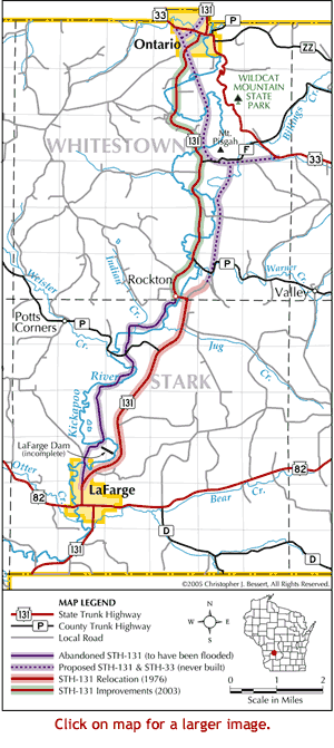
The route of STH-131 from LaFarge through Rockton to Ontario ran along the Kickapoo River, crossing it no less than eleven times in that stretch. Obviously, with a dam being constructed to hold back river waters to form a man-made lake, the highway would have to be relocated. The first segment of this relocation—from Adams St on the north side of LaFarge to just south of CTH-P northeast of Rockton—was built in the mid-1970s and opened to traffic in c.1976 as far as the new high bridge crossing the river—which would become part of the impoundment once the dam was completed—at Rockton. (The segment from the high bridge at Rockton northerly to the bluff top just shy of CTH-P was constructed, but was to not become part of the new highway until a new high-level bridge spanning the Warner Creek valley and the rest of the highway to the north was built. Part of this route survives today as Cut-Off Rd.)
Plans for the relocation of STH-131 on new alignment from Rockton northerly to Ontario took the new highway northerly along the high ground east of the proposed impoundment to the Mount Pisgah area near present-day CTH-F, where the new highway would meet up with a relocated STH-33 from the east. The combined STH-33/STH-131 would then swing around the south and west sides of Mount Pisgah, cross the new lake just northeast of the present STH-131 & CTH-F junction and head northerly, crossing the river/lake again twice before intersecting the existing alignments of STH-131 and STH-33 in Ontario. Not only would this proposed alignment have taken STH-131 out of the river valley and away from the rising waters of the new lake, but would have also placed nearby STH-33 onto a new, modern alignment, bypassing the twisting and turning route of that highway just southeast of Ontario. But, while a route had been chosen and, indeed, the first half mile northeast of the new Rockton high bridge constructed, various legal, political and cultural forces were at work that would negate the need for this new highway altogether.
As Al Anderson of the University of Wisconsin Extension writes in his excellent article titled "The LaFarge Dam":
...The project was plagued with problems. In 1970, the Federal Environmental Protection Act was passed, requiring that the project prepare an environmental impact statement. The La Farge dam was a very early example of a federal project preparing an environmental impact statement. Numerous environmental concerns were raised. There were a number of endangered species of plants and serious concerns were raised about the dam’s effect on water quality. The US Army Corps of Engineers (COE) made some provisions in the structure of the dam to address the water quality issues and the project was given the go-ahead for completion. By 1975, over half of the dam structure was completed and the state highway from La Farge to Rockton had been relocated. However, costs escalated due to delays caused by the environmental impact statement and modifications made to the plan. In 1975, Wisconsin Senator William Proxmire asked for a re-evaluation of the cost-benefit ratio for the dam and the project collapsed due to that analysis. The project came to a halt in 1975.
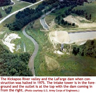 The half-finished dam languished in its unfinished state and plans for the
STH-131 relocation project from Rockton to Ontario similarly resided "on
the shelf" in limbo until a decision was made on what to do with the project.
Several proposals were floated, none of which could achieve any consensus.
Finally, in the early 1990s, community groups began deliberating on what
to do with the failed dam project. The final result included the transferring
of 1,200 acres of land acquired for the project to be held as a reserve for
the Ho-Chunk nation with the remaining 7,300 acres of land being transferred
to the State of Wisconsin to be held as public space, now called the Kickapoo
Valley Reserve.
The half-finished dam languished in its unfinished state and plans for the
STH-131 relocation project from Rockton to Ontario similarly resided "on
the shelf" in limbo until a decision was made on what to do with the project.
Several proposals were floated, none of which could achieve any consensus.
Finally, in the early 1990s, community groups began deliberating on what
to do with the failed dam project. The final result included the transferring
of 1,200 acres of land acquired for the project to be held as a reserve for
the Ho-Chunk nation with the remaining 7,300 acres of land being transferred
to the State of Wisconsin to be held as public space, now called the Kickapoo
Valley Reserve.
While the final land ownership transfer took place in 2000, the question of what to do with the remainder of STH-131 from Rockton to Ontario remained a pressing question. In August 2003, WisDOT Secretary Frank Busalacchi noted that stretch of STH-131 had only received "bare bones maintenance" for the previous few decades. "This route was desperately in need of attention. It featured deteriorated pavement, sharp curves, narrow lanes and no shoulders. It flooded regularly and the bridges were so decrepit that trucks weren't able to use them." The reason for the poor maintenance was likely the fact that the department was long under the impression that this particular portion of highway would be largely underwater once the dam was complete. It made little sense to pour major dollars into a highway which would be abandoned and flooded soon. That is, until the dam and impoundment project died...
WisDOT then undertook a project in the early 1990s to "complete" the STH-131 relocation from Rockton to Ontario, as it had originally planned. However, while local residents and business owners were slowly coming to consensus over the disposition of the Army Corps of Engineers-owned lands, the highway project ignited old arguments and reopened old wounds caused by the abandoned dam project. Transportation officials were designing a modern, efficient highway facility, while environmentalists were campaigning for as little change to the highway as possible. It was then, in 1996-98 that the "Route 131 Final Design Advisory Committee" was formed to find some sort of common ground so that WisDOT could move forward with improvements to the highway which were so desperately needed, but in a manner which preserved the qualities which were proving to be a major drawing card to the area for canoeists, bicyclists and tourists alike.
The committee goal, according to WisDOT's Gary Bolstad, was to "be as gentle to the land as we possibly could, but still end up with a design standard that was acceptable to the traveling public." The original STH-131 relocation plans, including the joint segment with STH-33 from Mount Pisgah to Ontario, were scrapped and the Department also acquiesced to a roadway which was not a sterile, straight ribbon of pavement. Several special features were incorporated into the revised STH-131 project plans, including a 45-mph design speed and posted speed limit, avoidance of many of the local natural and archeological sites, avoidance of natural features, inclusion of migratory bird nests under bridges, aesthetic facing on bridges made of stone, four river access locations and use of what was called a "minimum clear zone" where vegetation, slopes and other hazards were only cleared back a certain amount so as to preserve the rural character of the roadway. The old WisDOT "mapped corridor" was dropped and plans for the new roadway were drawn up.
Reconstruction on STH-131 from Rockton to Ontario began in April 2001 and was completed in August 2003 with a dedication ceremony held on the 15th of that month. In addition to the improvements made to the actual highway itself and the enhancements noted above, the newly-reconstructed highway also includes wide, paved shoulders suitable for bicycling. Nine bridges along the segment were either relocated, replaced or constructed, including seven river crossings and two so-called "land bridges."
While local citizen opposition groups quickly formed to combat the original highway relocation plans, WisDOT's interaction with locals and other impacted groups helped to forge a better design, resulting in the much-needed highway improvements, but at a much lower cultural and environmental cost. STH-131 itself is known to traverse some sizable local hills, but the LaFarge Dam and highway relocation project of the 1960s along with the cancellation of that project in the 1970s and the eventual formation of the Kickapoo Valley Preserve in the 1990s and 2000s provided much larger "hills" for this project to traverse.
Sources
- "The LaFarge Dam" by Al Anderson
- "STH-131: Mobility in Harmony with Environmental Stewardship" by Jerry Marks.
- "Groups Comment On Kickapoo River Highway 131 Reconstruction" letter by the New Transportation Alliance, Sierra Club, Wisconsin's Enviromental Decade and Citizens for a Better Environment
- "Kickapoo River Flood Damage Reduction, La Farge, Wisconsin" from the U.S. Army Corps of Engineers, St. Paul District
Additional Information
- Map of STH-131 in the Kickapoo Valley – large format version of the map included in the article above.
- STH-131 Photos: Rockton-Ontario, 1999/2005 – a set of five photographs illustrating some of the improvements made to STH-131 between Ontario and Rockton.
 The LaFarge Dam – an excellent article by Al Anderson of the University
of Wisconsin Extension and updated by Marcy West, Executive Director to
the Kickapoo Reserve Management
Board.
The LaFarge Dam – an excellent article by Al Anderson of the University
of Wisconsin Extension and updated by Marcy West, Executive Director to
the Kickapoo Reserve Management
Board.- STH-131:
Mobility in Harmony with Environmental Stewardship – an article
in the Fall 2004 issue of Wisconsin Transportation Builder by
Jerry Marks.
- Kickapoo Valley Reserve - website for the reserve comprising 8,569 acres
which were originally acquired for the creation of the impoundment.
- Kickapoo River Flood Damage Reduction, La Farge,
Wisconsin – (via archive.org) overview
page from the U.S. Army Corps
of Engineers, St. Paul District.
- Groups Comment On Kickapoo River Highway 131 Reconstruction – the New Transportation Alliance, Sierra Club, Wisconsin's Enviromental Decade and Citizens for a Better Environment, on Dec. 17, 1999, submitted a comment letter on the Highway 131 FEIS.
- Kickapoo Valley Scenic Route in Jeopardy;
State Highway 131: Quaint Road or Speedway? – (via archive.org) an article by Dave Ebbert
in the Spring 2000 edition of Wisconsin
Bicyclist.
- STH-131 Route Listing