Milwaukee Freeways: Airport Spur Freeway
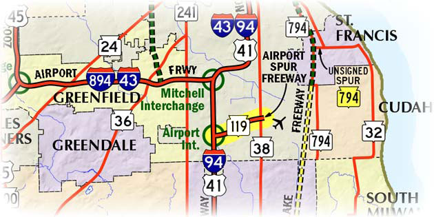
 The Airport Spur Freeway, commonly just called the "Airport Spur," is
a 1.89-mile long freeway in the southernmost portion of the City of Milwaukee
and designated STH-119 in its entirety. It serves as the primary connection
between General Mitchell International Airport and the I-94/I-41/US-41/North-South
Freeway. It begins at the Airport Interchange on I-94/I-41/US-41 and continues
a short distance to the east into the airport itself at the STH-38/Howell Ave interchange.
The Airport Spur Freeway, commonly just called the "Airport Spur," is
a 1.89-mile long freeway in the southernmost portion of the City of Milwaukee
and designated STH-119 in its entirety. It serves as the primary connection
between General Mitchell International Airport and the I-94/I-41/US-41/North-South
Freeway. It begins at the Airport Interchange on I-94/I-41/US-41 and continues
a short distance to the east into the airport itself at the STH-38/Howell Ave interchange.
The Airport Spur Freeway is the last true freeway built in Milwaukee County and was the only one of the five freeways involved in a November 5, 1974 countywide referendum—17 miles of freeway scheduled and budgeted, but stalled by opposition—to be constructed, even though all five were approved by voters. This was likely due not only to the freeways very short length at less than two miles, but also because of its perceived necessity by both the pro- and anti-freeway forces when wrangling over the future of the Milwaukee County freeway system. The Airport Spur was completed in 1978.
As the planning for the 2010–14 rebuilding of the I-94/I-41/US-41 corridor on the south side of Milwaukee was getting underway in 2006, local citizens and civic leaders were asked for their ideas about would could be done with the STH-119 freeway spur. Initial thoughts were that the Airport Spur could be converted to a more heavily-landscaped "gateway boulevard" instead of a standard four-lane freeway. In the end, though, the entire STH-119 freeway was reconstructed in 2012 largely as it was before, but with some minor, aesthetic improvements such as a slightly wider median to accommodate some natural plantings, a decorative median wall instead of just a plain cement barrier, and some additional areas set aside for decorative plantings closer to the edge of the right-of-way. Other than some minor geometric modifications to some of the freeway ramps, the Airport Spur was reconstructed largely as-is.
While officially a state trunk highway and fully a part of the state highway system, STH-119 was, for nearly three decades, an unsigned route. WisDOT, however, denoted STH-119 on their official state highway maps for most of that time and most commercial mapmakers (Rand McNally, Seeger, Milwaukee Map, Hedberg, Hudson, Mapquest, etc.) did so as well. Until April 2007, signs along I-94/US-41 at the STH-119 exit only pointed toward "Gen Mitchell Int'l Airport." Since then, signs along the North-South Freeway have pointed to both STH-119 as well as the airport. By 2010, a STH-119 route marker had been posted along the westbound spur just west of the STH-38/Howell Ave interchange as well as at the various on-ramps along Howell Ave and Grange Ave. At that point, Wisconsin was down to just two unsigned state trunk highways (both of them in Milwaukee Co): STH-341 and SPUR STH-794.
Note: The map below will be updated in the near future to show the many route designation changes from 2015.
Additional Information
- STH-119 Route Listing
- Signs recognize spur's dual identity – article from the April 29, 2007 Milwaukee Journal-Sentinel.
- Airport Spur may get a makeover – (via archive.org) article from the February 12, 2006 Milwaukee Journal-Sentinel.
- Wisconsin Highway 119 – photos of the new STH-119 exit signs off I-94/US-41 from Mark Hintz' website.
- Back to Milwaukee Freeways