Milwaukee Freeways: Rock Freeway
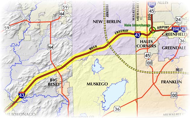
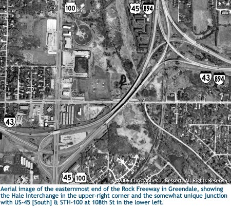
The Rock Freeway, designated as part of I-43 in its entirety, leads away from the southwestern "corner" of the Milwaukee area freeway system toward south-central Wisconsin. It begins at the Hale Interchange in Hales Corners, where I-894/I-41/US-41 & I-43 approach from the east via the Airport Freeway andI-894/I-41/US-41 & US-45 come in from the north via the Zoo Freeway, and continues westerly and southwesterly through Waukesha County toward Beloit (itself in Rock County, hence the name of the freeway). The "Rock Freeway" moniker, however, generally only applies to that part of the route in Milwaukee and Waukesha Counties. While most of the Rock is designated solely as I-43, the easternmost mile of the highway duals with US-45 between STH-100/108th St and the Hale Interchange.
In the early 1970s, the federal government denied the state's request to connect Milwaukee and Beloit with an Interstate, as well as a companion Milwaukee-to-Janesville route. Local and state officials still saw the need in having such a connection, and momentum pushed the project along, with or without Interstate route markers and funding. From WisDOT's "Wisconsin Highways 1945-1985,":
One of the many highway-promoting bodies was the "Highway 15 Committee" composed of such as Eugene H. Grobschmidt, the Milwaukee County Board Chairman; Henry W. Maier, Milwaukee Mayor; Martin F. Schreiber, Sr., Milwaukee City Council President; Martin F. Schreiber, Jr., a State Senator who later became Lieutenant Governor and Acting Governor, and George Whittow, then a Milwaukee alderman.
This committee published "15 x 72," a multi-color, 11x8-inch, 10 page promotional piece, that told why the improvement was "urgently needed ... the accommodate urban growth ... to open new areas ... to serve the Rock River Valley ... to complete regional arterials ... and to strengthen Wisconsin's economy." There were especially strong supportive quotes from Governor Warren P. Knowles and Lieutenant Governor Patrick J. Lucey. Hwy. 15 was dedicated as one of Wisconsin's last "Cadillac" highways, completed in 1976.
 The first segment of the Rock Freeway to open was completed in 1966
as part of the project to finish the route of I-894 around the south and
west sides of metropolitan Milwaukee. It was the 9/10th mile connector from
the Hale Interchange to the junction with US-45/STH-100/108th St in western
Greenfield. Since the US-45 route had been transferred to the new Zoo
Freeway upon its completion, this short connector bore only that designation for
the time being.
The first segment of the Rock Freeway to open was completed in 1966
as part of the project to finish the route of I-894 around the south and
west sides of metropolitan Milwaukee. It was the 9/10th mile connector from
the Hale Interchange to the junction with US-45/STH-100/108th St in western
Greenfield. Since the US-45 route had been transferred to the new Zoo
Freeway upon its completion, this short connector bore only that designation for
the time being.
In 1969, the first truly lengthy segment of the STH-15/Rock Freeway was completed and opened to traffic from US-45/STH-100/108th St to just west of CTH-F (modern-day STH-164) near Big Bend. In 1972, the year in which the "Highway 15 Committee" had hoped to have STH-15 completed, the Big Bend-to-East Troy segment was opened, while a year later the freeway was extended from East Troy to a connection with the US-12 freeway at Elkhorn. In late 1976, the Elkhorn to I-90 gap was completed; Milwaukee and Beloit were now connected by an Interstate-quality freeway.
For over a decade, the Rock Freeway carried traffic as a state trunk highway-designated freeway, but certain civic leaders in the area still longed for the perceived "prestige" that the Interstate route marker brought to such a highway. Since WisDOT had constructed the route to full freeway standards, they agreed to request an Interstate designation and on November 24, 1987, the FHWA agreed to replace STH-15 on the Rock in its entirety with such a designation. I-43, which had ended in downtown Milwaukee at the Marquette Interchange, was piggybacked onto the I-94/North-South Freeway from there southerly to the Mitchell Interchange, then continued concurrently with I-894 along the Airport Freeway to the Hale Interchange at the beginning of the Rock. From there, I-43 continued southwesterly to a new terminus at I-90 in Beloit.
Note: The map below will be updated in the near future to show the many route designation changes from 2015.