Milwaukee Freeways: West Bend Freeway
 The
West Bend Freeway is rather unique among the freeways of Greater Milwaukee
for several reasons. First, it exists only in Washington County, never entering
Milwaukee or Milwaukee County. Second, it was constructed in the 1980s, at
a time when all freeway construction closer to the Milwaukee metro area had
come to a complete halt. Third, it was opened to traffic first as a two-lane "Super-2" freeway
before being converted to a normal four-lane facility.
The
West Bend Freeway is rather unique among the freeways of Greater Milwaukee
for several reasons. First, it exists only in Washington County, never entering
Milwaukee or Milwaukee County. Second, it was constructed in the 1980s, at
a time when all freeway construction closer to the Milwaukee metro area had
come to a complete halt. Third, it was opened to traffic first as a two-lane "Super-2" freeway
before being converted to a normal four-lane facility.
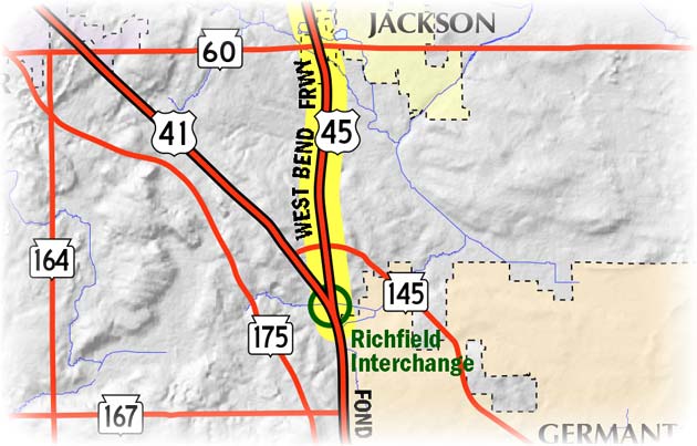
Sometimes called the "West Bend Bypass," this freeway runs 14 miles from the Richfield Interchange near the community of the same name northwest of Germantown in Washington County northerly past Jackson and West Bend, before merging back into the former route of US-45 just north of West Bend. The West Bend Freeway is designated as US-45 throughout.
Civic leaders in West Bend first began campaigning for a relocation of US-45, which ran through the center of the city via Main St, as early as the 1950s. Major improvements in the US-41 corridor were underway in Washington Co in the early 1950s, resulting in a modern four-lane divided highway on completely new alignment. Those in West Bend, eight miles east of US-41, saw a bypass or other relocation of US-45 in the area as a way to reduce congestion on Main St through town and improve safety as well. Senator Frank Panzer, who served in the Wisconsin legislature from 1931 until his death in 1969, championed the bypass, but, alas, he would never see it complete in his lifetime.
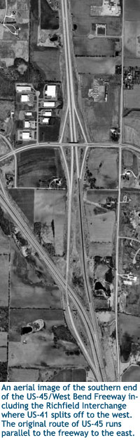
After being simply a line on planning maps for many years, actual construction on the highway began in the mid-1980s. At the southern end, the new highway began at a reformulated Richfield Interchange between Germantown and Jackson near the small hamlet of Richfield. Formerly, the interchange consisted of US-41 veering northwesterly while the ramps to US-45 led directly into the existing two-lane highway, now Shadow Ln and CTH-P. The ramps were reconfigured and moved slightly to the northwest to feed directly into the new highway heading northerly, parallel to the former route approximately one-quarter mile to the west.
When the West Bend Bypass first opened to traffic in the fall of 1986, it was a "Super-2" freeway, which is a limited-access highway with interchanges and overpasses, as along a "normal" freeway, but consisting of only two undivided lanes. Essentially, a "Super-2" is a freeway where only one-half of the facility is constructed, usually with the other "side" being built as traffic volumes warrant. In the case of US-45 between Germantown and West Bend, the two-lane facility was converted into a full, four-lane divided freeway in 1990, bringing the West Bend Freeway to its present configuration.
Note: The map below will be updated in the near future to show the many route designation changes from 2015.